Wadden Sea
| The Wadden Sea* | |
|---|---|
| UNESCO World Heritage Site | |
 |
|
| State Party | |
| Type | Natural |
| Criteria | viii, ix, x |
| Reference | 1314 |
| Region** | Europe and North America |
| Inscription history | |
| Inscription | 2009 (33st Session) |
| * Name as inscribed on World Heritage List. ** Region as classified by UNESCO. |
|
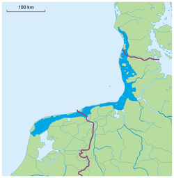
The Wadden Sea (Dutch: Waddenzee, German: Wattenmeer, Low German:Wattensee, Danish: Vadehavet, West Frisian: Waadsee) is an intertidal zone in the southeastern part of the North Sea. It lies between the coast of northwestern continental Europe and the range of Frisian Islands, forming a shallow body of water with tidal flats and wetlands. It is rich in biological diversity. In 2009, the Dutch and German parts of the Wadden Sea were inscribed on UNESCO's World Heritage List.[1]
The Wadden Sea stretches from Den Helder in the Netherlands in the southwest, past the great river estuaries of Germany to its northern boundary at Skallingen north of Esbjerg in Denmark along a total length of some 500 km and a total area of about 10,000 km².
The islands in the Wadden Sea are called the Wadden Sea Islands or Frisian Islands, named after the Frisians. However, on the westernmost Dutch island, Texel, the Frisian language has not been spoken for centuries. The Danish Wadden Sea Islands have never been inhabited by Frisians. The outlying German island of Heligoland, although ethnically one of the Frisian Islands, is not situated in the Wadden Sea.
The German part of the Wadden Sea was the setting for the 1903 Erskine Childers novel "The Riddle of the Sands".
Contents |
Nature

The word wad is Dutch for "mud flat" (Low German and German: Watt, Danish: Vade). The area is typified by extensive tidal mud flats, deeper tidal trenches (tidal creeks) and the islands that are contained within this, a region continually contested by land and sea. The landscape has been formed for a great part by storm tides in the 10th to 14th centuries, overflowing and carrying away former peat land behind the coastal dunes. The present islands are a remnant of the former coastal dunes.
The islands are marked by dunes and wide, sandy beaches towards the North Sea and a low, tidal coast towards the Wadden Sea. The impact of waves and currents, carrying away sediments, is slowly changing the layout of the islands. For example, the islands of Vlieland and Ameland have moved eastwards through the centuries, having lost land on one side and grown on the other.
The Wadden Sea is famous for the rich flora and fauna, especially birds. Hundred of thousands of waders (shorebirds), ducks, and geese use the area as a migration stopover or wintering site, and it is also rich habitat for gulls and terns.[2] Today, a great part of the Wadden Sea is protected in cooperation of all three countries; see Wadden Sea National Parks for the protected areas within the German borders.

The governments of the Netherlands, Denmark and Germany have been working together since 1978 on the protection and conservation of the Wadden Sea. Co-operation covers management, monitoring and research, as well as political matters. Furthermore, in 1982, a Joint Declaration on the Protection of the Wadden Sea was agreed upon to co-ordinate activities and measures for the protection of the Wadden Sea. In 1997, a Trilateral Wadden Sea Plan was adopted.[3]
The Wadden Sea was designated a Ramsar wetland of international importance on May 14, 1987.
In June of 2009, it was placed on the World Heritage list by Unesco.[4]
Recreation


Many of the islands have been popular seaside resorts since the 19th century.
Mudflat hiking (Dutch: Wadlopen), i.e., walking on the sandy flats at low tide, has become popular in the Wadden Sea.
It is also a popular region for pleasure boating.
References
- ↑ [1]Wadden Sea World Heritage Site] at www.waddensea-worldheritage.org. Retrieved on 29 Apr 10.
- ↑ Couzens, Dominic (2008). Top 100 Birding Sites of the World. University of California Press. pp. 27–29. ISBN 978-0-520-25932-4.
- ↑ The Trilateral Wadden Sea Cooperation at www.waddensea-secretariat.org. Retrieved on 29 Apr 10.
- ↑ World heritage sites: slave outpost and Buddhist mountain on the list – but Wales has to wait. Guardian.co.uk. Retrieved on 2009-07-07.
External links
- Vollmer, M.; Gulberg, Maluck, Marrewijk (2001). "Landscape and Cultural Heritage in the Wadden Sea Region - Project Report". Wadden Sea Ecosystem 12. http://www.waddensea-secretariat.org/lancewad/report.html.
- Knottnerus, Otto S. (2005). "History of human settlement, cultural change and interference with the marine environment". http://www.xs4all.nl/~ottoknot/werk/Sylt.html.
- Secretariat of The Trilateral Cooperation on the Protection of the Wadden Sea
- Official Tourist Information for the Northernmost part of the National Park: The Danish Wadden Sea
- The Wadden Sea at the UNESCO World Heritage Centre
- Wadden Sea World Heritage
|
|||||||||||||||||
|
||||||||||||||||||||
|
||||||||||||||||||||
|
|||||||